


In today’s world there are people who are triggered when they think a photographer might be about to photograph them or their property. People can be suspicious, angry, confrontational, and feel they have a right to absolute privacy wherever they go and that photographers don’t have a right to photograph anything in public view without permission. Many of these same people also are completely comfortable with having government traffic cameras monitoring them as they drive through town, or stores capturing facial recognition when they shop, or having their selfie images flung far and wide on the internet. I always try to be respectful to others but I won’t sacrifice my First Amendment rights because someone has feelings which are not congruent with the law.
I have not had any problems photographing the devastation caused by the Eaton Fire, but I have been questioned more than once about what I was doing, and I am fine with that. People in the burn area have been victims of looting and souvenir hunters, and it is good people to watch out for their neighborhood. Soon after the fire I had business cards made with images of the fire on them and links to my website. When people ask what I am doing I introduce myself, explain that I was born and raised in the area, I talk about the importance of documenting the event, and I give them a business card so they can check out my photographs. Once people understood who I am and why I am photographing I never had a problem. I often end up in long conversations with these people as they are happy to tell someone their story. A lot of people in the burn areas are hurting and need someone to listen to them. A sad thing I have heard on a couple occasions were stories about outside people visiting the area to sightsee the damage and removing artifacts from homes, people’s property, as if they were souvenirs from the trip.
I often photograph from the street and when I do move in I walk in on lawns, pathways, or driveways. Since most the houses in the area were built on raised foundations with hard wood floors it is too dangerous go on to the debris where I have no idea about the depth or the dangers of the materials underneath me. The best photographs have been from the outside looking in too. I don’t move or take items I just photograph what I see, searching out the best composition of the item. If a lot has caution tape or no trespassing signs up I respect them and don’t go past them.
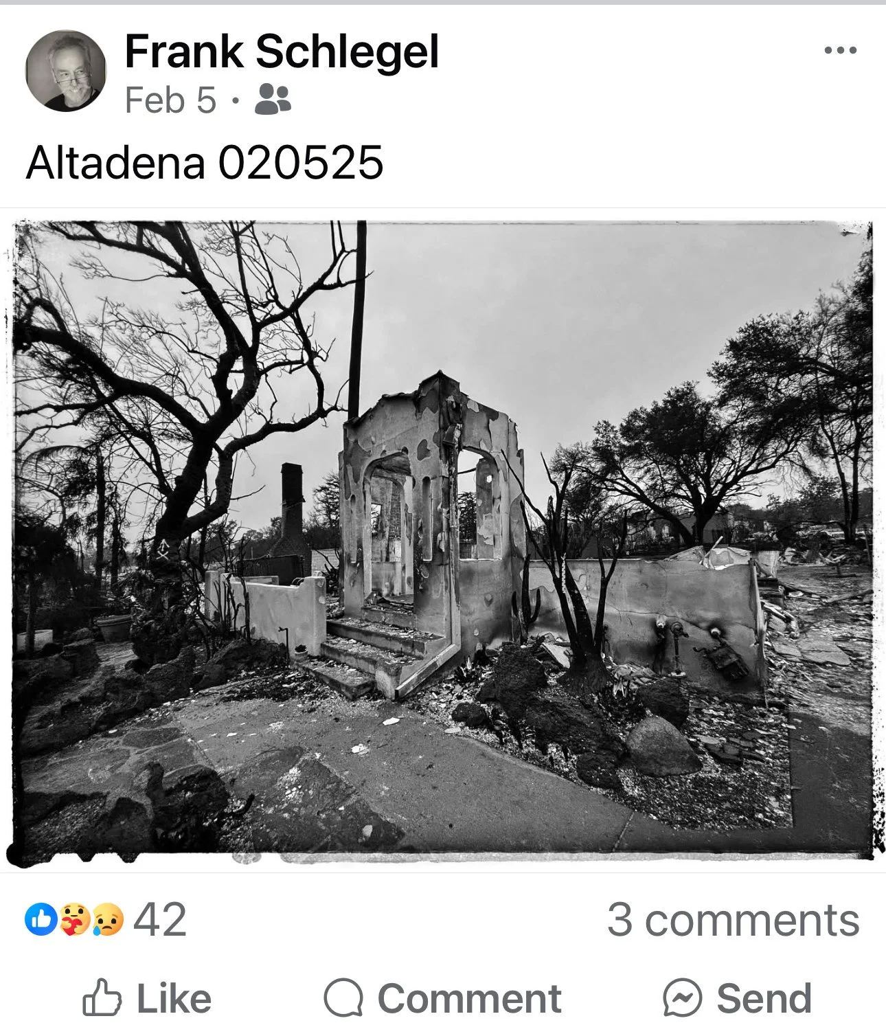
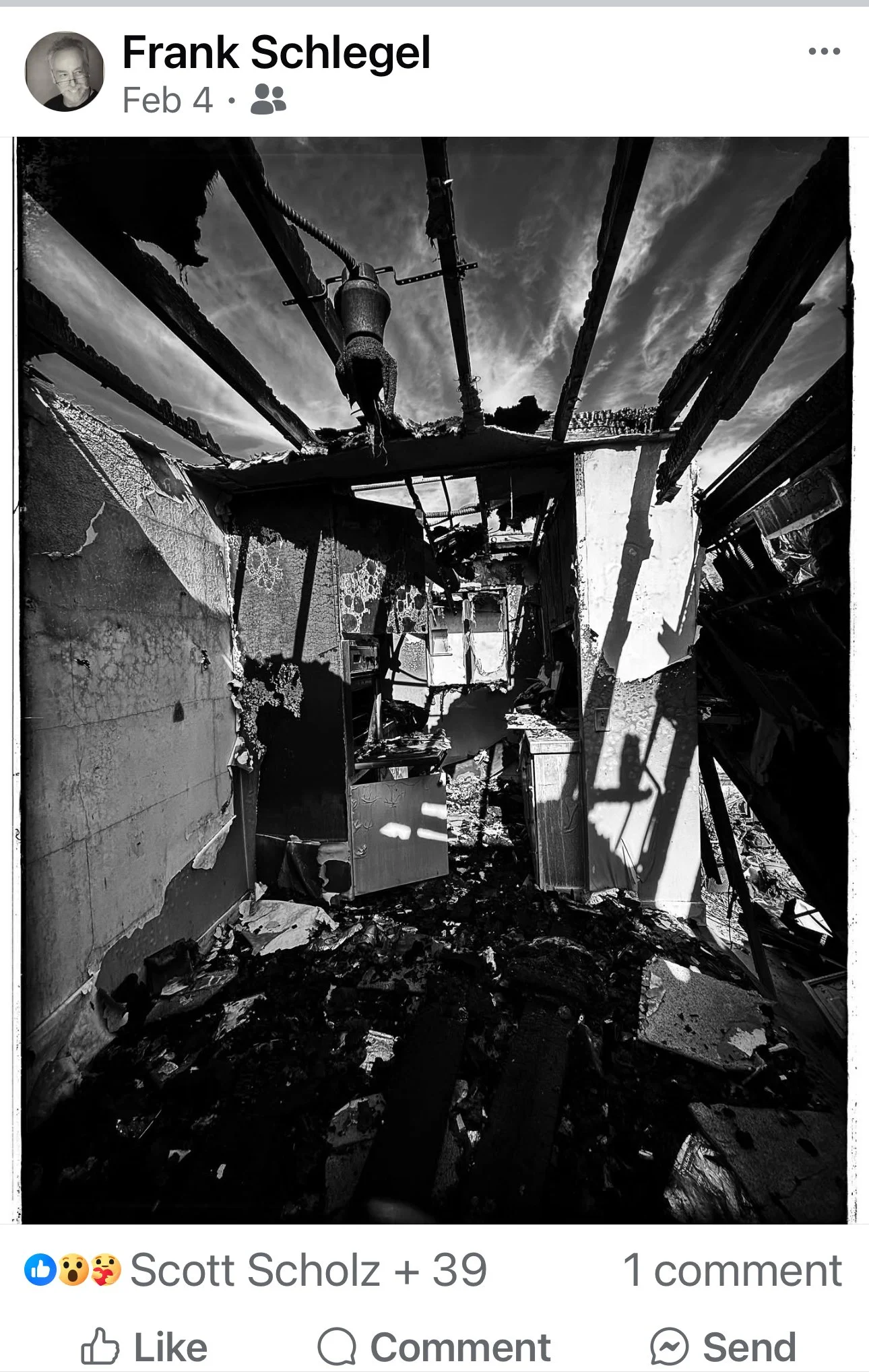
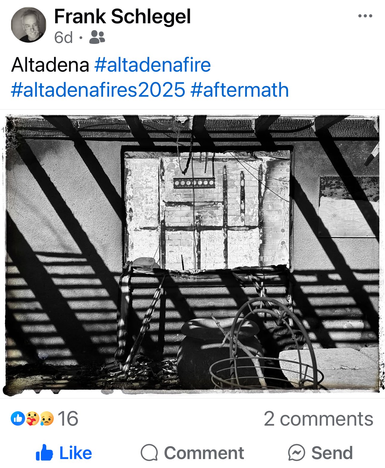
The process of photographing in the Eaton Fire area is unlike anything else I have photographed once I got past the initial part of the flames. It is slightly like my Cemetery Portfolio with static graphic elements which I can photograph from numerous angles and return to rephotograph at different times to get the exact light I am looking for. The only pressure I have had is when the cleanup started I ended up in a race with the Army Corps of Engineers to get my images before they levelled up all the lots.
The weight of these images is heavier than most anything I have ever photographed, the only thing harder I can really think of was photographing Officer Russ Miller’s funeral in 2000 because he was a close friend. The closeness of the subject matter is really similar and it may be harder because this area is where I grew up and our childhood memories are often some of the strongest we have. I definitely feel the loss and grief every time I am photographing up there.
I have always loathed press photographers who put on a long lens to capture someone’s tears at a time of loss. We all know what loss is like, for me those images can sometimes feel exploitative. I can envision some press photographers proud to have “gotten the shot” while not really considering what the person in their frame is dealing with. Something which really separates me with this portfolio is I don’t have to move on to the next story, I am staying there in my neighborhood with these people. It’s weird sometimes how draining making five hundred exposures over a few hours up there can be. Especially when I travel to someplace like Chicago, I can easily capture 10x thar many images in a weekend and feel great. The drive to work on the Eaton Portfolio is strong, almost a little addictive and that includes all the postproduction tasks.
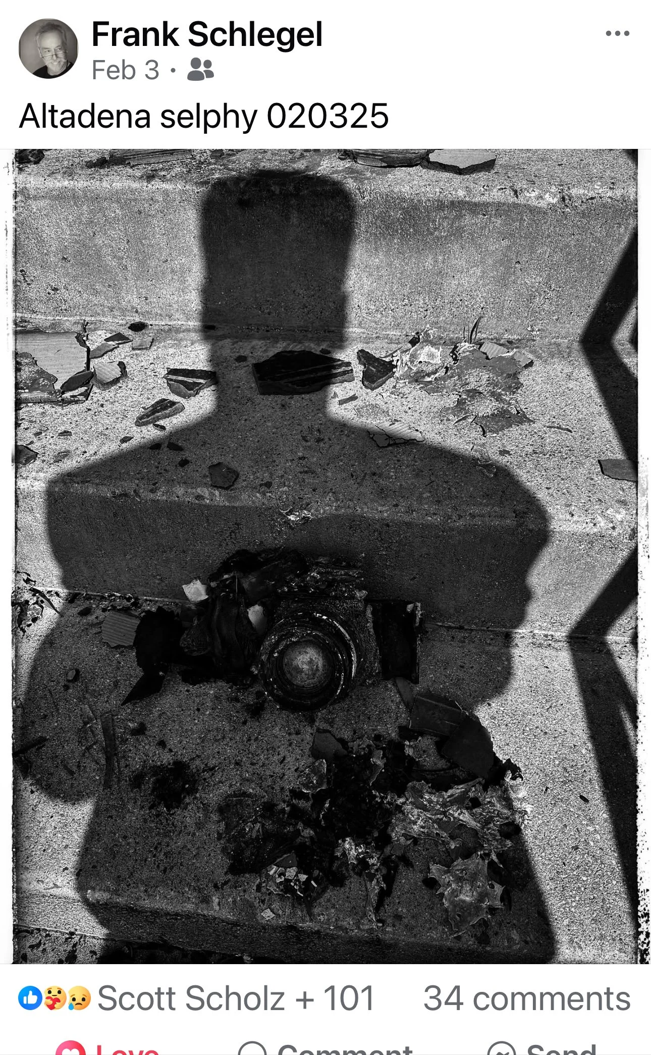
I almost feel guided at times with this portfolio as if it has been assigned to me. I am also finding things to photograph which I can’t explain how I found them, and I am capturing amazing images in poor lighting conditions. I am working methodically and with good equipment, but it is more than that.
I found it interesting that several people were willing to talk with me for a few minutes about their loss but declined to let me photograph them.
This post is long, but I felt I needed to speak about ethics related to the Eaton Fire Portfolio somewhere on my website and do so now. There are people in today’s world who love to challenge the intentions of others, often anonymously, and I wanted to be proactive explaining why I am photographing in Altadena and hopefully limit any misconceptions in the future.
——————————————————————————————————————————
As an additional exercise I asked the Chatbot of Britannica: What are the ethics of photography and got the following:
Source: Britannica (5)
The ethics of photography involve considerations of objectivity, manipulation, privacy, and social impact. Ethical standards in photography are essential to maintaining trust and promoting responsible practices.
Key Ethical Considerations
Objectivity vs. Manipulation Photography has long been considered an objective medium, accurately recording reality. However, digital technologies allow for easy manipulation of images, blurring the line between reality and fabrication. Photojournalists and documentarians have reacted cautiously to digital imaging, with journalistic codes of ethics established to regulate the alteration of digital images.
Privacy and Harassment Paparazzi methods have led to claims of privacy invasion and harassment, especially concerning celebrities. Legislation exists to regulate paparazzi behavior, stipulating that they may be prosecuted if they threaten, stalk, intimidate, or cause distress to their subjects.
Social Impact and Documentation Photography's power to persuade and inform has led to social documentation, capturing theoretically objective descriptions and arousing sympathy. Social documentation can be used to examine contemporary society, but it can also be falsified for dramatic effect.
Civil Liberties The expansion of photography into surveillance and facial recognition technologies has intensified debates about its impact on civil liberties.
Ethical Principles
Fundamentally, ethical photography should adhere to principles of honesty, respect, and responsibility. It is critical to avoid manipulating images in ways that distort the truth, to respect individuals' privacy, and to consider the potential social impact of photographic work. Upholding these principles is essential for maintaining the integrity and trustworthiness of photography as a medium.
Britannica also stated Ethics is defined in the discipline concerned with what is morally good and bad and morally right and wrong. The term is also applied to any system or theory of moral values or principles.
AI gave a pretty concise and detailed explanation covering most the issues of ethics related to photography.